


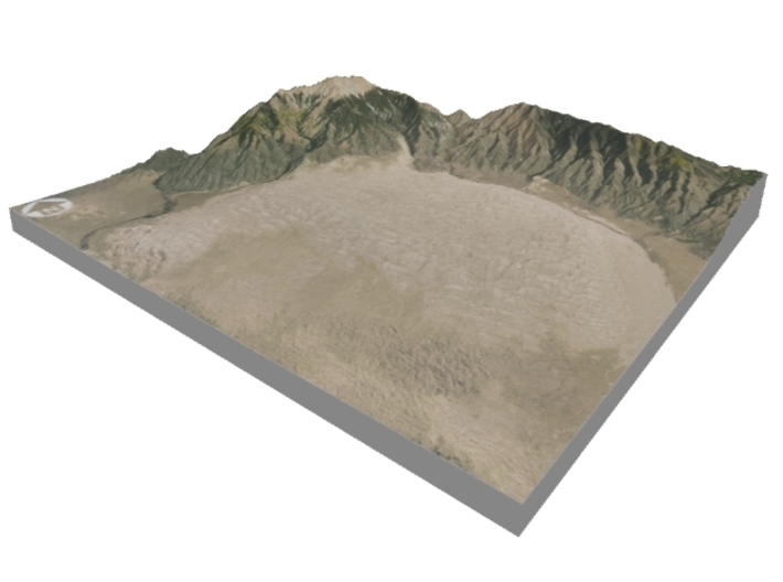

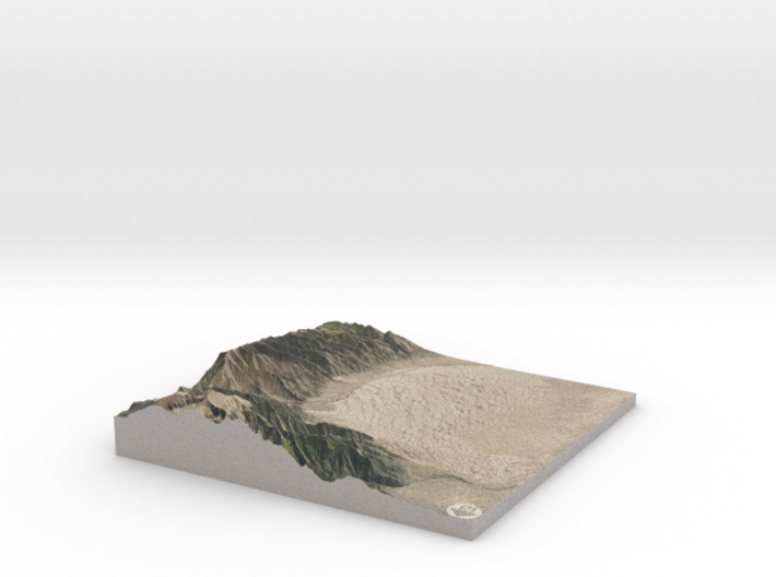
Great Sand Dunes National Park Map: 6"x6"
Made by
Print With Shapeways
 Choose Your Material
 Choose your color and finish
$151.83
Have a question about this product?
contact the designerYou must be logged in and verified to contact the designer.
Product Description
Interactive 3D View
If you would like a custom relief map, contact me through my website or through Shapeways. Check out photos of my other 3D prints.
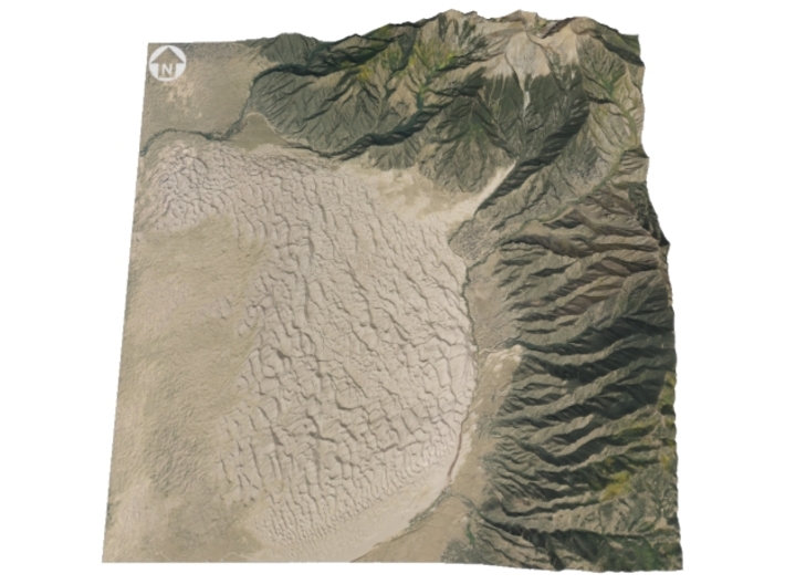
Great Sand Dunes National Park and Preserve is a national park that conserves an area of large sand dunes up to 750 feet (229 m) tall[4] on the eastern edge of the San Luis Valley, and an adjacent national preserve located in the Sangre de Cristo Range, in south-central Colorado, United States.[5] The park was originally designated Great Sand Dunes National Monument on March 17, 1932 by President Herbert Hoover. The original boundaries protected an area of 35,528 acres (55.5 sq mi).[6] A boundary change and redesignation as a national park and preserve was authorized on November 22, 2000 and then established by an act of Congress on September 24, 2004.[2] The park encompasses 107,342 acres (167.7 sq mi) while the preserve protects an additional 41,686 acres (65.1 sq mi) for a total of 149,028 acres (232.9 sq mi).[1]
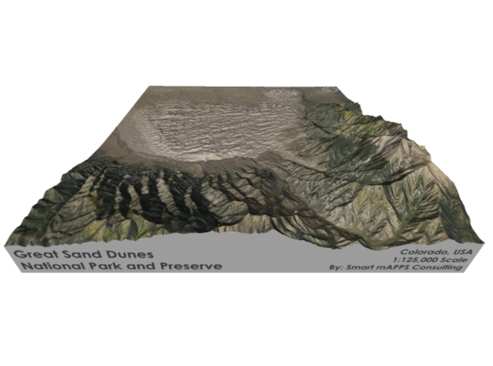
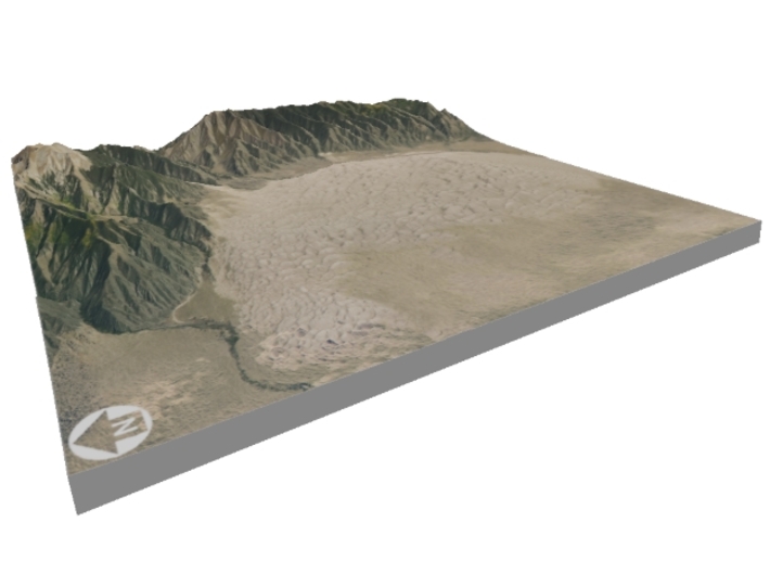
The park contains the tallest sand dunes in North America.[7] The dunes cover an area of about 30 sq mi (78 km2) and are estimated to contain over 5 billion cubic meters of sand.[8] Sediments from the surrounding mountains filled the valley over geologic time periods. After lakes within the valley receded, exposed sand was blown by the predominant southwest winds toward the Sangre de Cristos, eventually forming the dunefield over an estimated tens of thousands of years.[9] The four primary components of the Great Sand Dunes system are the mountain watershed, the dunefield, the sand sheet, and the sabkha.[8] Ecosystems within the mountain watershed include alpine tundra, subalpine forests, montane woodlands, and riparian zones.[10]
Evidence of human habitation in the San Luis Valley dates back about 11,000 years. The first historic peoples to inhabit the area were the Southern Ute Tribe, while Apaches and Navajo also have cultural connections in the dunes area. In the late 17th century, Don Diego de Vargas—a Spanish governor of Santa Fe de Nuevo México—became the first European on record to enter the San Luis Valley. Juan Bautista de Anza, Zebulon Pike, John C. Frémont, and John Gunnison all travelled through and explored parts of the region in the 18th and 19th centuries. The explorers were soon followed by settlers who ranched, farmed and mined in the valley starting in the late 19th century. The park was first established as a national monument in 1932 to protect it from gold mining and the potential of a concrete manufacturing business.[11]
Visitors must walk across the wide and shallow Medano Creek to reach the dunes in spring and summer months. The creek typically has a peak flow from late May to early June in most years. From July through April, the creek is usually no more than a few inches deep, if there is any water at all.[12] Hiking is permitted throughout the dunes with the warning that the sand surface temperature may reach 150 °F (66 °C) in summer.[13] Sandboarding and sandsledding are popular activities, both done on specially designed equipment which can be rented just outside the park entrance or in Alamosa.[14] Visitors with street-legal four-wheel drive vehicles may continue past the end of the park's main road to Medano Pass on 22 miles (35 km) of unpaved road, crossing the stream bed of Medano Creek nine times and traversing 4 miles (6.4 km) of deep sand.[15] Hunting is permitted in the preserve during the months of autumn, while hunting is prohibited within national park boundaries at all times.[16] The preserve encompasses nearly all of the mountainous areas north and east of the dunefield, up to the ridgeline of the Sangre de Cristos.
Source: Wikipedia
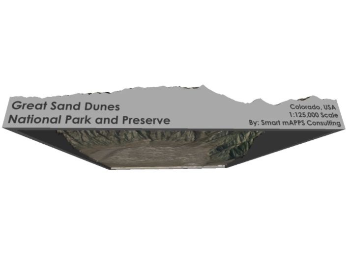
The model is created at a scale of 1:125,000 with 1.75x vertical exaggeration. It features a built-in base, so it sits perfectly on a desk or in a frame.
Model Data Sources: USDA, USGS
If you would like a custom relief map, contact me through my website or through Shapeways. Check out photos of my other 3D prints.
Great Sand Dunes National Park and Preserve is a national park that conserves an area of large sand dunes up to 750 feet (229 m) tall[4] on the eastern edge of the San Luis Valley, and an adjacent national preserve located in the Sangre de Cristo Range, in south-central Colorado, United States.[5] The park was originally designated Great Sand Dunes National Monument on March 17, 1932 by President Herbert Hoover. The original boundaries protected an area of 35,528 acres (55.5 sq mi).[6] A boundary change and redesignation as a national park and preserve was authorized on November 22, 2000 and then established by an act of Congress on September 24, 2004.[2] The park encompasses 107,342 acres (167.7 sq mi) while the preserve protects an additional 41,686 acres (65.1 sq mi) for a total of 149,028 acres (232.9 sq mi).[1]
The park contains the tallest sand dunes in North America.[7] The dunes cover an area of about 30 sq mi (78 km2) and are estimated to contain over 5 billion cubic meters of sand.[8] Sediments from the surrounding mountains filled the valley over geologic time periods. After lakes within the valley receded, exposed sand was blown by the predominant southwest winds toward the Sangre de Cristos, eventually forming the dunefield over an estimated tens of thousands of years.[9] The four primary components of the Great Sand Dunes system are the mountain watershed, the dunefield, the sand sheet, and the sabkha.[8] Ecosystems within the mountain watershed include alpine tundra, subalpine forests, montane woodlands, and riparian zones.[10]
Evidence of human habitation in the San Luis Valley dates back about 11,000 years. The first historic peoples to inhabit the area were the Southern Ute Tribe, while Apaches and Navajo also have cultural connections in the dunes area. In the late 17th century, Don Diego de Vargas—a Spanish governor of Santa Fe de Nuevo México—became the first European on record to enter the San Luis Valley. Juan Bautista de Anza, Zebulon Pike, John C. Frémont, and John Gunnison all travelled through and explored parts of the region in the 18th and 19th centuries. The explorers were soon followed by settlers who ranched, farmed and mined in the valley starting in the late 19th century. The park was first established as a national monument in 1932 to protect it from gold mining and the potential of a concrete manufacturing business.[11]
Visitors must walk across the wide and shallow Medano Creek to reach the dunes in spring and summer months. The creek typically has a peak flow from late May to early June in most years. From July through April, the creek is usually no more than a few inches deep, if there is any water at all.[12] Hiking is permitted throughout the dunes with the warning that the sand surface temperature may reach 150 °F (66 °C) in summer.[13] Sandboarding and sandsledding are popular activities, both done on specially designed equipment which can be rented just outside the park entrance or in Alamosa.[14] Visitors with street-legal four-wheel drive vehicles may continue past the end of the park's main road to Medano Pass on 22 miles (35 km) of unpaved road, crossing the stream bed of Medano Creek nine times and traversing 4 miles (6.4 km) of deep sand.[15] Hunting is permitted in the preserve during the months of autumn, while hunting is prohibited within national park boundaries at all times.[16] The preserve encompasses nearly all of the mountainous areas north and east of the dunefield, up to the ridgeline of the Sangre de Cristos.
Source: Wikipedia
The model is created at a scale of 1:125,000 with 1.75x vertical exaggeration. It features a built-in base, so it sits perfectly on a desk or in a frame.
Model Data Sources: USDA, USGS
Details
What's in the box:
Great-Sand-Dunes-6x6-125k

Dimensions:
Success Rate:
First To try.
What's this?
Rating:
Mature audiences only.


