


Mt. Whitney, California, 1:50000
Made by
Print With Shapeways
 Choose Your Material
 Choose your color and finish
$107.00
Have a question about this product?
contact the designerYou must be logged in and verified to contact the designer.
Product Description
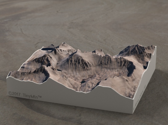
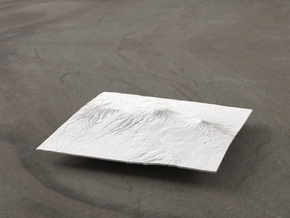
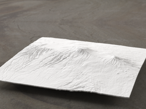
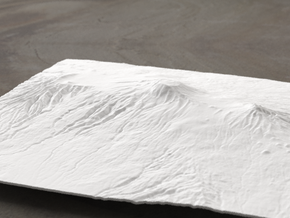
If you're not familiar with Mt. Whitney or the High Sierras, do yourself a favor and hit Google image search right now. The extreme ruggedness of the terrain and the endless sunny days make it a photographer's and armchair mountain appreciator's dream. It was not without excitement that this model was prepared for Shapeways. Within the mere 14 square miles covered by this model are dozens of peaks, severe cliff faces, moraines, cirques, and tarns.
Mt. Whitney is the highest peak in the lower 48 states and marks the Southern end of the John Muir Trail. Named after the famous environmentalist and naturalist, this 210-mile-long trail starts in Yosemite National Park and rarely drops below 8000' while passing through the heart of the Sierra Nevadas.
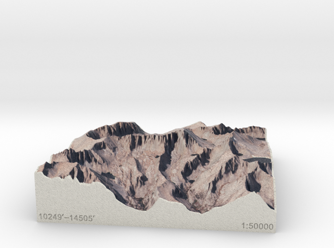
Model scale is 1:50000
Model covers an area approximately 3.7 by 3.7 miles
Altitudes covered: 10249' to 14501'
There is no vertical exaggeration applied to this model. This is a true-to-life scale model of a real place.
Click here for more sizes.
Click here for other 1:50000 models.
TinyMtn models are most affordable in the "Sandstone" and "White Strong and Flexible" materials. This model is in "Sandstone," which is a glued gypsum material. When you receive the model it will be ready for display, though it may smell funny and need some time to air out. "Sandstone" models are much more brittle than "White Strong and Flexible" models, but feel more like light stone. Do not soak it in water, though you can safely seal it with Polycrylic or a similar water-based clear spray sealant. Read more about this popular material here.
These models have been optimized for the above materials, and are not offered in other materials for strength or cost reasons. If you need one in another material, please tinymtnbiz@gmail.com and we'll do our best to fulfill your request.
(C) 2017 TinyMtn (TM)
Model created using GDAL, NetPBM, Gmsh, Carve, MeshLab, and other custom software
Contains modified Copernicus Sentinel data from 2016
Copernicus Open Access Hub is https://scihub.copernicus.eu/dhus
Source of digital elevation and aerial orthoimagery data: U.S. Geological Survey
The USGS home page is https://www.usgs.gov/
Mt. Whitney is the highest peak in the lower 48 states and marks the Southern end of the John Muir Trail. Named after the famous environmentalist and naturalist, this 210-mile-long trail starts in Yosemite National Park and rarely drops below 8000' while passing through the heart of the Sierra Nevadas.
Model scale is 1:50000
Model covers an area approximately 3.7 by 3.7 miles
Altitudes covered: 10249' to 14501'
There is no vertical exaggeration applied to this model. This is a true-to-life scale model of a real place.
Click here for more sizes.
Click here for other 1:50000 models.
TinyMtn models are most affordable in the "Sandstone" and "White Strong and Flexible" materials. This model is in "Sandstone," which is a glued gypsum material. When you receive the model it will be ready for display, though it may smell funny and need some time to air out. "Sandstone" models are much more brittle than "White Strong and Flexible" models, but feel more like light stone. Do not soak it in water, though you can safely seal it with Polycrylic or a similar water-based clear spray sealant. Read more about this popular material here.
These models have been optimized for the above materials, and are not offered in other materials for strength or cost reasons. If you need one in another material, please tinymtnbiz@gmail.com and we'll do our best to fulfill your request.
(C) 2017 TinyMtn (TM)
Model created using GDAL, NetPBM, Gmsh, Carve, MeshLab, and other custom software
Contains modified Copernicus Sentinel data from 2016
Copernicus Open Access Hub is https://scihub.copernicus.eu/dhus
Source of digital elevation and aerial orthoimagery data: U.S. Geological Survey
The USGS home page is https://www.usgs.gov/
Details
What's in the box:
Mt. Whitney, California, 1:50000
Dimensions:
Success Rate:
First To try.
What's this?
Rating:
Mature audiences only.