


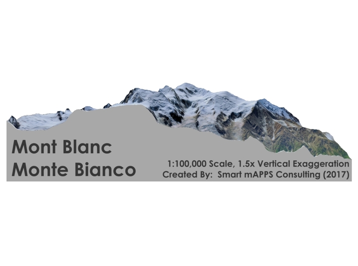


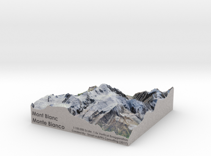
Mont Blanc Map: 1:100K
Made by
Print With Shapeways
 Choose Your Material
 Choose your color and finish
$169.18
Have a question about this product?
contact the designerYou must be logged in and verified to contact the designer.
Product Description
Interactive 3D Viewer
If you would like a custom relief map, contact me through my website or through Shapeways.
Check out photos of my other 3D prints.
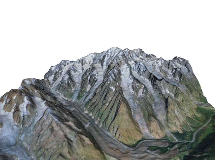
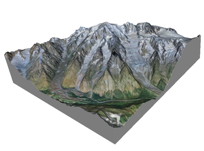
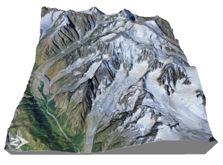
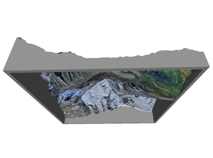
One of the Seven Summits, Mont Blanc or Monte Bianco, both meaning "White Mountain", is the highest mountain in the Alps and the highest in Europe west of Russia after the Caucasus peaks.[3] It rises 4,808 m (15,774 ft)[1][4] above sea level and is ranked 11th in the world in topographic prominence.[5] The mountain lies in a range called the Graian Alps, between the regions of Aosta Valley, Italy, and Savoie and Haute-Savoie, France. The location of the summit is on the watershed line between the valleys of Ferret and Veny in Italy and the valleys of Montjoie, and Arve in France. The Mont Blanc massif is popular for mountaineering, hiking, skiing, and snowboarding.
The three towns and their communes which surround Mont Blanc are Courmayeur in Aosta Valley, Italy, and Saint-Gervais-les-Bains and Chamonix in Haute-Savoie, France. The latter town was the site of the first Winter Olympics. A cable car ascends and crosses the mountain range from Courmayeur to Chamonix, through the Col du Géant. The 11.6 km (7¼ mi) Mont Blanc Tunnel, constructed between 1957 and 1965, runs beneath the mountain and is a major trans-Alpine transport route.
Source: Wikipedia
The model is created at a scale of 1:100,000 with 1.5x vertical exaggeration. It features a built-in base, so it sits perfectly on a desk or in a frame.
Model Data Sources: JAXA
If you would like a custom relief map, contact me through my website or through Shapeways.
Check out photos of my other 3D prints.
One of the Seven Summits, Mont Blanc or Monte Bianco, both meaning "White Mountain", is the highest mountain in the Alps and the highest in Europe west of Russia after the Caucasus peaks.[3] It rises 4,808 m (15,774 ft)[1][4] above sea level and is ranked 11th in the world in topographic prominence.[5] The mountain lies in a range called the Graian Alps, between the regions of Aosta Valley, Italy, and Savoie and Haute-Savoie, France. The location of the summit is on the watershed line between the valleys of Ferret and Veny in Italy and the valleys of Montjoie, and Arve in France. The Mont Blanc massif is popular for mountaineering, hiking, skiing, and snowboarding.
The three towns and their communes which surround Mont Blanc are Courmayeur in Aosta Valley, Italy, and Saint-Gervais-les-Bains and Chamonix in Haute-Savoie, France. The latter town was the site of the first Winter Olympics. A cable car ascends and crosses the mountain range from Courmayeur to Chamonix, through the Col du Géant. The 11.6 km (7¼ mi) Mont Blanc Tunnel, constructed between 1957 and 1965, runs beneath the mountain and is a major trans-Alpine transport route.
Source: Wikipedia
The model is created at a scale of 1:100,000 with 1.5x vertical exaggeration. It features a built-in base, so it sits perfectly on a desk or in a frame.
Model Data Sources: JAXA
Request a custom order
and get this product personalized just for you
Details
What's in the box:
Mont-Blanc-6x6-100k

Dimensions:
Success Rate:
First To try.
What's this?
Rating:
Mature audiences only.


