

Monte Rosa, Switzerland/Italy, 1:100000 Explorer
Made by
Print With Shapeways
 Choose Your Material
 Choose your color and finish
$129.00
Have a question about this product?
contact the designerYou must be logged in and verified to contact the designer.
Product Description
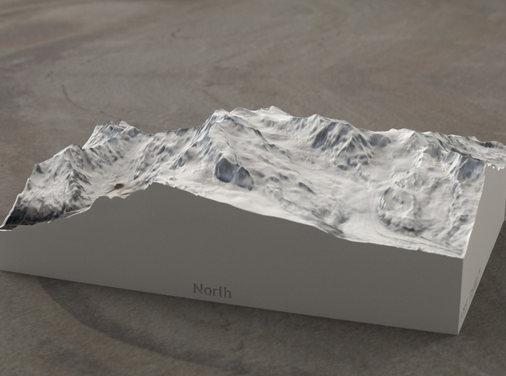
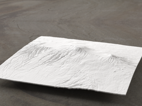
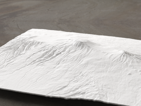
At 4634m, Monte Rosa is the second-highest mountain in the Alps, and comprises a large central massif with size central peaks. The two highest of these, Dufourspitze and Dunantspitze, are fully within the Swiss canton of Valais, while the lower four are on the Italian side. The Swiss side also contains the Monte Rosa Hut, which is a five-sided, high-tech, nearly-self-sufficient building owned by the Swiss Alpine Club SAC, and at the beginning of the standard climbing route. The Italian side is on the border of the provinces of Aosta Valley and Piedmont, and contains the higher faces of the mountain, which drops a steep 2500m to the Ghiacciao (Glacier) de Belvedere, and nearly 3300m (over two miles) to the village of Pecetto.
This model of Monte Rosa contaians the entire massif, plus the Northern ridge almost to Cima di Jazzi, the Eastern ridge out to Pizzo Bianco, and contains the edge of the town of Pecetto to the Northeast and the ends of the valleys above Alagna Valsesia and Staffal to the South. West of the massif, you'll see Liskamm, Castor, Pollux, and finally Breithorn Orientale. To the Northwest, the model contains the famous Monte Rosa Hut and ends on the Gornergletscher, just missing Gornergrat and Riffelhorn.
The Explorer series of TinyMtn models is designed to break our usual impression of mountains. We generally see mountains one at a time, from a distance, and from the ground. While all TinyMtn models give you a fresh perspective on any one peak, the Explorer series presents mountains in identical scale, and shifted up so that sea level is at the bottom of the base. Thus, when you set two Explorer models next to each other, you will immediately notice which is taller, which rises more from its base, which is more massive, and so on. Plus, all Explorer models come in full color, making them just that much more realistic.
Model scale is 1:100000
Model covers an area approximately 15 by 10 km
Altitudes covered: 1363m to 4634m
There is no vertical exaggeration applied to this model. This is a true-to-life scale model of a real place.
Click here for more sizes.
Click here for other 1:100000 models in the Explorer series.
TinyMtn models are most affordable in the "Sandstone" and "White Strong and Flexible" materials. This model is in "Sandstone," which is a glued gypsum material. When you receive the model it will be ready for display, though it may smell funny and need some time to air out. "Sandstone" models are much more brittle than "White Strong and Flexible" models, but feel more like light stone. Do not soak it in water, though you can safely seal it with Polycrylic or a similar water-based clear spray sealant. Read more about this popular material here.
These models have been optimized for the above materials, and are not offered in other materials for strength or cost reasons. If you need one in another material, please tinymtnbiz@gmail.com and we'll do our best to fulfill your request.
(C) 2017 TinyMtn (TM)
Model created using GDAL, NetPBM, Gmsh, Carve, MeshLab, and other custom software
J. Takaku, T. Tadono, K. Tsutsui : Generation of High Resolution Global DSM from ALOS PRISM, The International Archives of the Photogrammetry, Remote Sensing and Spatial Information Sciences, pp.243-248, Vol. XL-4, ISPRS TC IV Symposium, Suzhou, China, 2014. [PDF file]
T. Tadono, H. Ishida, F. Oda, S. Naito, K. Minakawa, H. Iwamoto : Precise Global DEM Generation By ALOS PRISM, ISPRS Annals of the Photogrammetry, Remote Sensing and Spatial Information Sciences, pp.71-76, Vol.II-4, 2014. [PDF file] https://doi.org/10.5069/G94M92HB
Data Access Acknowledgement: This material is based on data services provided by the OpenTopography Facility with support from the National Science Foundation under NSF Award Numbers 1226353 & 1225810
Contains modified Copernicus Sentinel data from 2016
Copernicus Open Access Hub is https://scihub.copernicus.eu/dhus
Source of digital elevation data: Viewfinder Panoramas
Viewfinder Panoramas provides cleaned and modified versions of DEM data from ASTER GDEM, SRTM, and local sources. Data used without permission.
The Viewfinder Panoramas home page is https://www.viewfinderpanoramas.org/
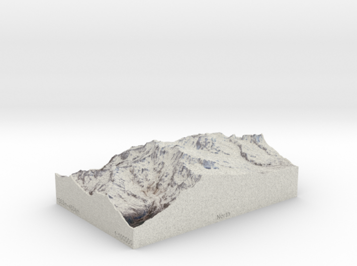
Details
What's in the box:
Monte Rosa, Switzerland/Italy, 1:100000 Explorer

Dimensions:
Success Rate:
First To try.
What's this?
Rating:
Mature audiences only.
